
Earth Rover Challenge IROS 2026: First Place
Team ManseRobot from the Computer Vision Group at Tampere University won the Earth Rover Challenge at IROS 2026 in Pittsburgh (28–30 September 2026), finishing first overall out of 12 teams from around the world. The challenge asks a simple question: can an AI policy drive a sidewalk rover the way a human can? Our answer was a single learned navigation stack that drove robots in cities across the Americas and Africa, through indoor hallways using nothing but a camera, and on the 50-mile marathon from UC Berkeley to Stanford.
The team was Sasanka Kuruppu Arachchige, Lauri Suomela and Abhimanyu Bhowmik, supervised by Prof. Joni-Kristian Kämäräinen. This builds directly on our runner-up finish at the ICRA 2025 edition.
Overall
1st · 12.50
NYU 9.00 · Anna University 7.00
Indoor
5 / 5
Checkpoints, zero interventions
Marathon
Best score
UC Berkeley → Stanford
The challenge
Every team drives the same standardised Earth Rover sidewalk robots, which are deployed in different cities and controlled remotely over 4G. All computation runs off-board: camera, GPS and IMU data arrive at around 20 Hz with roughly half a second of latency, and velocity commands go back the same way. Missions are scored by difficulty, so the total rewards both reach and consistency. The IROS 2026 edition had four tracks over three days:
- Urban: follow GPS checkpoints along sidewalks and street crossings in cities including Colón (Panama), La Plata (Argentina) and Selebi-Phikwe (Botswana), plus an unseen-environment mission.
- Off-road: reach image goals on trails, slopes and gravel, without GPS.
- Indoor: reach image goals through hallways, atriums and labs, again with camera only.
- Marathon: new this year. A cross-domain endurance run from UC Berkeley to Stanford, about 50 miles in seven legs, driven by a single policy.
Results
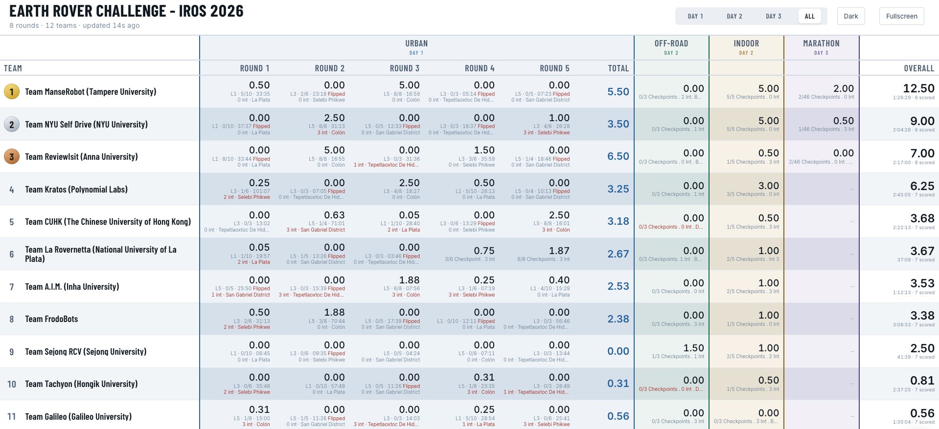
| # | Team | Urban | Off-road | Indoor | Marathon | Overall |
|---|---|---|---|---|---|---|
| 1 | ManseRobot (Tampere University) | 5.50 | 0.00 | 5.00 | 2.00 | 12.50 |
| 2 | NYU Self Drive (NYU) | 3.50 | 0.00 | 5.00 | 0.50 | 9.00 |
| 3 | ReviewIsit (Anna University) | 6.50 | 0.00 | 0.50 | 0.00 | 7.00 |
As the organisers put it, ManseRobot finished in the top two in the Urban, Indoor and Marathon tracks, and that consistency is what won the overall title. Highlights include a complete 8/8-checkpoint urban run in Colón, Panama, with no interventions, a perfect 5/5 indoor run, and the best marathon score of the event.
How it works
The whole system comes from two of our recent papers. Instead of hand-tuning a pipeline for each track, we used the same learned policies everywhere and added a thin safety layer around them.
- A navigation policy trained on real data at scale. The driving policy comes from our study Data Scaling for Navigation in Unknown Environments (RA-L 2026), trained on thousands of hours of crowd-sourced FrodoBots driving data. For this edition we retrained it to take RGB images together with traversability maps, and to output actions through a diffusion head, using the LUMI supercomputer.
- Traversability as a safety layer. SAM-TP, the pixel-wise traversability model from GeNIE, is projected into a bird's-eye-view map around the robot. A repulsive field pushes the commanded motion away from untraversable space, and a recovery state gets the robot unstuck when it stalls.
- GPS goals in the city. In the urban track the policy follows sub-goals derived from the GPS checkpoints, with explicit heading control so the robot points at the next checkpoint before committing to a direction.
- Image goals without GPS. Indoors we run FAINT (ICRA 2026), our image-goal navigation transformer trained largely in simulation, on a topological map: a sequence of images recorded along the route. The robot localises itself in that map with EigenPlaces place-recognition features, and a cone detector and tracker confirms each checkpoint.
Urban: Colón, Panama
Indoor: one-shot image-goal navigation
The indoor track has no GPS and no prior map: the only information about the building is a short sequence of images along the route. We built and tested the indoor pipeline on corridors in our own lab in Tampere, then deployed it single-shot on the competition building at NYU, completing all five checkpoints with zero interventions.
What's next
We are turning the system and the lessons from the competition into a paper, ManseRover: Cross-Domain Navigation from Scaled Real Data and Simulation (tentative title), targeting IROS 2027. It brings together our work on data scaling for navigation and FAINT: large real-world datasets give a policy that generalises across cities, and simulation-trained image-goal navigation handles the places GPS cannot reach. This page will link to the paper when it is out.
Links
- Earth Rover Challenge: rules, tracks and past editions
- Official podium announcement by BitRobot, the challenge sponsor
- Data Scaling for Navigation in Unknown Environments (RA-L 2026)
- Synthetic vs. Real Training Data for Visual Navigation (FAINT, ICRA 2026)