
#Aerial Robotics #LiDAR Inertial Odometry #State Estimation #Robot Safety #Drone #PX4
A real forest flight of our quadrotor, mapped by AGIptive-LIOM: from take-off through the forest and back to the take-off point, then the whole loop from above (offline replay, 10× speed, points coloured by height).
A quadrotor that flies on LiDAR-inertial odometry closes its control loop on the estimate, so a divergence that nobody notices can cost the vehicle. Many of the failures we met came from the sensors rather than the scene: clock steps, a blocked view, starting while moving, an IMU that clips at impacts. AGIptive-LIOM is a flight-safe, failure-aware LiDAR-inertial odometry for quadrotors: it guards against these faults, knows when its estimate is degraded, and tells the flight controller.
Highlights
- Guards against real sensor faults. A timing layer tells a clock step from a data dropout using the other sensor's timestamps and repairs the step; further guards handle a blocked view, a moving start and merged scans.
- Knows when it is degraded. An onboard health monitor that needs no ground truth reports OK, DEGRADED or FAILED with every scan, including a drift indicator for directions the LiDAR cannot see.
- Tells the flight controller. The monitor sets the quality of the vision message to PX4, so PX4's own filter stops fusing a failed estimate. In simulated closed-loop flights this kept PX4's filter on the truth while the odometry failed.
- Judged by how it fails. Eight methods on identical public recordings, fault injection and closed-loop simulated flights, with failures counted by cause. It is not the most accurate method, and real flights in the loop are still to come.
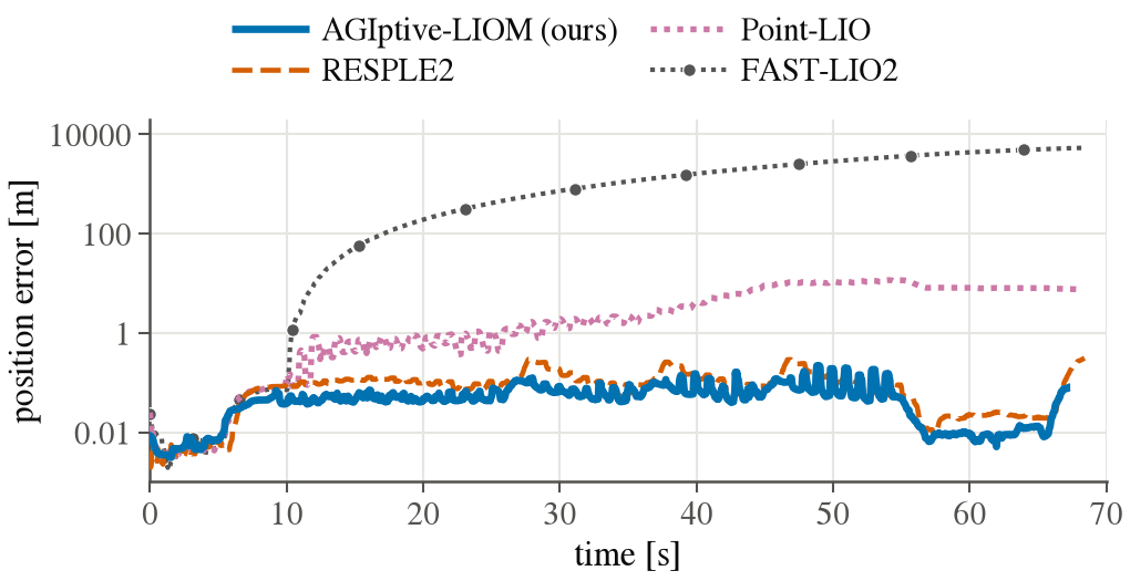
A hopping robot whose internal IMU clips at every landing (public HOPPER data, one run per method). FAST-LIO2 diverges and Point-LIO drifts; AGIptive-LIOM and RESPLE2 stay at a few centimetres.
Code will be released once the paper is submitted.